Abstract
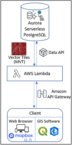
Cloud computing enables performing computations and analysis tasks and sharing services in web-based computer centres instead of local desktop systems. One of the most used areas of cloud computing is Geographic Information Systems (GIS) applications. Although Desktop GIS products are still used in the community frequently, Web GIS and Cloud GIS applications have drawn attention and have become more efficient for users. In this study, a serverless Cloud GIS framework is implemented for land valuation platform. In order to store, analyse, and share geospatial data, Aurora Serverless PostgreSQL database is created on Amazon Web Services (AWS). While adopting Aurora Serverless PostgreSQL as database management system, a simple point in polygon analysis conducted to compare the performances with Amazon RDS instance. Results showed that serverless database responded to the query faster and scaled up during high workload to decrease latency. Hence, parcel vector data, which conveys ownership information and land values attributes, is shared directly from the PostGIS database as vector tiles. Besides S3 and AWS Lambda services are used for storing and disseminating raster-based land value map tiles. To visualize all shared data and maps through a web browser, open source web mapping library Mapbox GL JS is used.