October 23rd 2011, M7.2 Tabanli - VAN Earthquake
Latest update: 01.11.2011, 10:24
The information collected and compiled by the Istanbul Technical University, Institute of Earthquake Engineering and Disaster Management regarding the October 23rd, 2011 M7.2 Tabanli-Van, Turkey Earthquake can be found at this website.
Please revisit our webiste for updates.Institute of Earthquake Engineering and Disaster Management
Istanbul Technical University
Sections
- Epicenter and magnitude of the earthquake
- Recorded strong ground motions
- Structural damage investigation - NEW
- Geotechnical investigations - (will be added soon)
- Links
- References
Structural Damage Investigation
The preliminary results from the initial damage reconnaissance performed by members of Istanbul Technical University, Institute of Earthquake Engineering and Disaster Management are presented below:
1 – Erciş
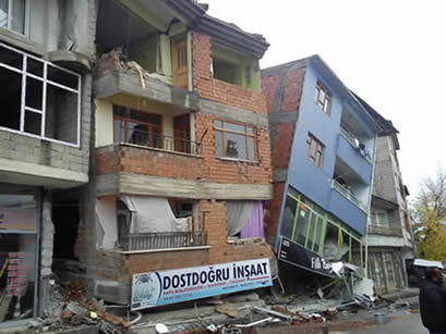
The effects of the earthquake were the severest in Erciş. Many buildings had sustained noticeable damage. The lack of engineering supervision is conceived to be the main cause of damage in the low rise buildings. Inadequate concrete quality, insufficient reinforcement detailing and presence of soft ground stories were seen as the key factors that resulted in severe damage in RC buildings. Collapse of the ground story was the main failure mechanism in some RC buildings. The major causes of damage in brick masonry buildings were identified as the insufficient mortar quality and lack of the rigid roof diaphragm. Ground settlements have been observed in the neighborhood of the clock tower at the center of Erciş. Most likely, these settlements were related to the softening/failure of the underlying soil layers. In Erciş, a total of 65 buildings had collapsed.
2 - Van (City Center)
The ratio of the buildings in the city of Van which were damaged due to the October 23rd, 2011 M7.2 Tabanlı-Van earthquake was observed to be low. The buildings across two of the main avenues: Kazım Karabekir Avenue and İki Nisan Avenue were quickly inspected by performin a walk-down survey. The major causes of damage were observed to be the presence of soft stories and heavy overhangs, the discontinuities of the lateral load resisting system being, the insufficient transverse reinforcement being used, and the pounding in between neighboring structures. The facade claddings which made it difficult see the severity of structural damage, were frequently utilized in the buildings around main avenues. In addition, construction of added stories which are not accounted for when designing the building is another important cause of damage. Cracked facade infill walls, damaged chimneys could be seen in many buildings throughout the city.
It is important to note that after the November 9th, 2011 M5.6 Edremit-Van earthquake, buildings in the city of Van sustained heavier damage compared to that after M7.2 Tabanlı earthquake. At the time of writing this report a detailed inspection of the damages of the M5.6 had not been made. Hence, the effects of this subsequent earthquake are not covered in detail in this report.3 - Alaköy
Building stock in Alaköy village mostly consists of adobe buildings constructed using local materials. During the inspections, it was seen that the damage was most frequent in the adobe buildings. Disproportionate weights of the roofs and the material deterioration were identified as the main causes of heavy damage. For the masonry buildings constructed using stone or clay brick, the use of mud paste was identified as another important cause of damage. This phenomenon could as well be observed in the collapsed walls of the gardens. The barns were observed to constitute a large portion of the heavily damaged and collapsed structures.
The elementary school building, kindergarten building and the teachers’ residences had a reinforced concrete (RC) structural system which was uncommon in the village. No significant structural damage was observed in the school building and the kindergarten. The non-structural damage was very limited. As a result, the three RC buildings were identified to be safe for occupancy. The gymnastics building which is a part of the school had collapsed completely. The stones forming the structural systems of this masonry building seemed to have completely disintegrated due to the earthquake. An RC building was identified to have heavy damage which rendered the structure unsafe. This building consisted of two blocks separated by lap joints. The larger block and the smaller block had two and three stories, respectively.
Liquefaction induced lateral spreading cracks were observed at a site located approximately 3 kms away from the village. A villager told that he observed sand erupting out from the cracks on the ground (i.e. sand boil). Slope failure induced landslides were observed at the sides of the Van – Ağrı highway.
4 – Gedikbudak Village
The building stock of the village consists of one story adobe and stone masonry structures. Some portion of the buildings had collapsed and others had significant wall damage. Especially, the use of mud paste as the mortar is suspected to be the primary cause of the damage. Another important cause was the lack of rigid diaphragms at the roofs that should constrain dynamic response of the walls.
Primary school building of the village had collapsed. This building had two large RC structural walls along the longer plan axis whereas no structural walls could be seen along the perpendicular axis. It was seen that the collapse had taken place along the shorter axis of the building. Quality of concrete is estimated to be below the average. Unacceptably large (i.e. diameters exceeding ~10 cm) aggregate pieces could be seen in the concrete used. The beam-column joint regions were observed to have insufficient transverse reinforcement.
The buildings that were used as depots typically have two long parallel walls along their longer axis and have only façade walls on along the shorter axis. These walls had toppled of since they did not have any rigid connections in between them. The mosque building at the village had large stone masonry walls and had collapsed completely. The minaret structure had partially collapsed after the first earthquake and the remaining part had a high risk of collapse.
5 - Yaylıyaka Village
The school building had no damage. The masonry mosque building which had horizontal and vertical lintels had sustained significant damage. In addition, the stairs of the building had noticeable damage as well. Adobe and stone masonry buildings render the majority of the structures. Majority of buildings have sustained significant wall damage and some of the buildings have collapsed. A common cause of damage was observed to be the use of mud paste as the main mortar in the structures. The lack of rigid roof diaphragms has played a significant role in the occurrence of damage.
6 - Tabanlı Village
The school building at the village had no damage. The houses in the village are adobe, stone masonry and brick masonry structures. Even though Tabanlı village has been reported to be located at the epicenter of the M7.2 earthquake, the damage ratio was lower than that would be expected typically. Some cracking at the walls, disconnections at the edges and few collapses were observed.
7 - Muradiye Village
The strong motion recording station that was closest to the epicenter of the earthquake was inspected. No damage was observed at the meteorological station building near which the ground motion recording station is located. Likewise, only minor cracks were observed at the Muradiye State Hospital building. It was reported that the level of damage at Muradiye was lower than the threshold beyond which the structural safety is affected.
8 - Automobile Industry Building Complex near Van
Reinforced concrete buildings at the complex consist of a ground story and a mezzanine floor. The roofs are constructed as RC plates. The shear failures of the middle supporting columns of the mezzanine floors were common in many of the buildings. In addition, noticeable cracks had opened up at the boundaries of the infill walls. Based on the observable damage, the buildings were identified to have moderate damage.
9 - Technical Investigation of the Public and Administirative Buildings
Our team performed a quick inspection of a set of public buildings in Van upon request by the governorship. Following groups of buildings were inspected:
- Public health authority main building (1 building)
- City Police Department main building and branches (3 buildings)
- New court house (1 building)
- New state prison (1 building)
- Residences of the government officers (10+ buildings)
The results from these inspections were presented to the governor.
Reconnaisance Team
| Prof. Dr. Ertaç ERGÜVEN (Inst. of Earthquake Engineering and Disaster Management, Director) Prof. Dr. Zekai CELEP Prof. Dr. Ayfer ERKEN Asst. Prof. Dr. Pınar ÖZDEMİR ÇAĞLAYAN Asst. Prof. Dr. Beyza TAŞKIN Asst. Prof. Dr. Ufuk YAZGAN Res. Asst. Dr. Atilla SEZEN Res. Asst. Dr. Reşat OYGUÇ Res. Asst. Ülgen MERT TUĞSAL |
|
Acknowledgements
Our institute is thankful to Prof. Dr. Muhammed ŞAHİN (ITU Rector), Mr. Munir Karaloğlu (Major of Van), Ms. Behice SOLDUK (City and Regional Planner, M.Sc.), Mr. Gökhan ÇEBİ (AFAD, Div. of Planning and Mitigation)and Mr. Davut ŞAHİN (AFAD, Div. of Recovery).
Photos
Photos from October 26th, 2011
Photos from October 27th, 2011
| Photos October 28th, 2011 posted below |
Other sample photos
Epicenter and time
| Date, Time: | 23.10.2011, 13:41:21 |
| Town/Province: | Tabanli, Van (TURKEY) (Map) |
| Mw | Ml | Depth [km] | Coordinates | Institution | Link |
| 6.7 | 19.02 | 38.68 N 43.47 E | Disaster and Emergency Management Presidency (AFAD) | Sayfa | |
| 7.2 | 6.6 | 5 | 38.758 N 43.360 E | Kandilli Observatory (KOREI) | Sayfa |
| 7.1 | 16 | 38.691 N 43.497 E | U.S. Geological Survey (USGS) | Sayfa | |
| 7.2 | 10 | 38.86 N 43.48 E | European-Mediterranean Seismological Centre (EMSC) | Sayfa | |
| 7.1 | 15 | 38.67 N 43.58 E | Earthquake Information Service, Postdam (GEOFON) | Sayfa | |
| 7.3 | 10 | 38.86 N 43.48 E | Swiss Seismological Service (SED) | Sayfa |
Centroid moment solution by USGS suggests that the earthquake is related to a compressional trust fault system located to the North-East of Van, Turkey.
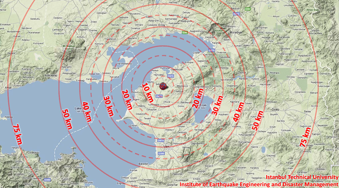
Figure 1. Epicentral distances. Click here for a larger map (Topographic map source: Google Maps)
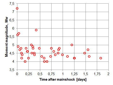
Figure 2. Aftershock decay rate
Ground motion intensity
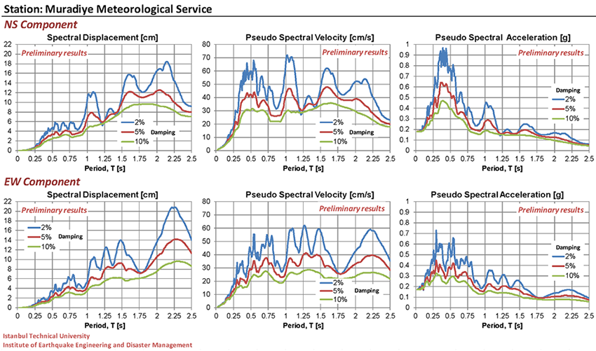
Figure 3. Preliminary spectra for the ground motions recorded at the Muradiye Meteorological Service (strong motion) station. These spectra are obtained after a simple linear baseline correction of the raw accleration records. Refined filtering methods will be utilized to correct these records soon. We thank to the Disaster and Emergency Management Presidency (AFAD) for providing these strong motion records.
Reported Damage
Latest update: 31/10/11, 17:30| Location | Life loss | Injured | Collapsed Buldings |
| Merkez, Van | 95 | 350 | 10 |
| Erciş, Van | 169 | 750 | 55 |
| Diğer | 337 | 3052 | 2197 |
| Toplam | 601 | 4152 | 2262 |
Source: AFAD, Anadolu Agency, nvtmsnbc
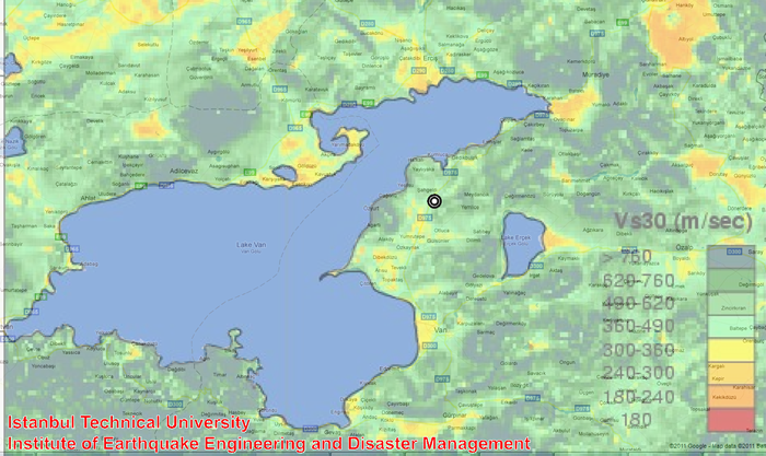
Figure 4. Topography based approximate Vs30 (m/s) estimates (Wald and Allen, 2009). Click here for a larger map. (Vs30 values are from the USGS Global Vs30 Map Server).
Major Historical Earthquakes (in the region)
| Year | Location | Magnitude | Life loss | Damaged Buildings |
| 1941 | Ercis, Van | Ms 5.9 | 192 | 600 |
| 1945 | Catak, Van | Ms 5.8 | - | - |
| 1972 | Center, Van | Ms 5.2 | - | - |
| 1976 | Caldiran - Muradiye, Van | Ms 7.5 | 3840 | 9232 |
| 1977 | Ercis, Van | Ms 5.2 | - | - |
Sources:
1) B.U. Kandilli Observatory and Earthquake Research Institute
2)
Disaster and Emergency Management Presidency (AFAD)
3) Gülkan et al. (1978)
Weather Condition Prediction for Van
| Prediction | ||
| Date | Temperature (°C) | Condition |
| November, 1st | -2 / 8 | Partly cloudy |
November, 2nd |
-1 / 9 | Partly cloudy |
| November, 3rd | -1 / 8 | Cloudy |
| November, 4th | -3 / 5 | Sleety |
| November, 5th | -4 / 6 | Sleety |
Source: Turkish State Meteorological Service
Our Students' Efforts
Some of our graduates and students actively participated in the search and rescue operations as well as aid coordination efforts. Cem Behar who is a graduate of our institute volunteered in the search and rescue operations together with Galip Kartoğlu who is currently enrolled in our disaster management program. In addition, Eda Ates who is enrolled in the same program volunteered in the aid coordination efforts. The report and the presentation prepared by their team (GEA) summarizes their efforts.
Acknowledgements
The help and support provided by the Istanbul Technical University Rectorate is greatly appreciated.
Contact
Please send your comments to Asst. Prof. Dr. Ufuk Yazgan (ufukyazgan@itu.edu.tr).
Links
Disaster and Emergency Management Presidency (AFAD)
Bogazici University, Kandilli Observatory and Earthquake Research Institute (KOERI)
U.S. Geological Survey (USGS) - PAGER Loss Estimates
Earthquake Engineering Research Institute (EERI)
Middle East Technical University, Earthquake Engineering Research Center (EERC)
European-Mediterranean Seismological Centre (EMSC)
GFZ German Research Centre for Geosciences (GEOFON)
Swiss Seosmological Service (SED)
References
- Allen, T. I. and Wald, D.J. (2009). "On the Use of High-Resolution Topographic Data as a Proxy for Seismic Site Conditions (VS30)", Bulletin of the Seismological Society of America, Vol. 99, No. 2A, pp. 935-943. (PDF)
- Gülkan, P., Gürpınar, A., Çelebi, M., Arpat, E., and Gencoğlu, S., (1978). "Engineering report on the Muradiye-Çaldıran, Turkey Earthquake of 24 November 1976", National Academy of Sciences, Washington D.C.(PDF)
